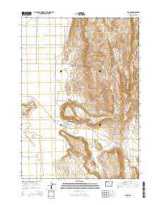
2014 Map of Crane
USGS Topo · Published 2014About this map
The high desert community of Crane sits at the junction of Or-78 and Crane-Buchanan Rd, serving as a focal point in the Harney Basin. This 2014 survey captures a landscape defined by volcanic landforms and managed water resources, where Crane Butte and the Crane Creek Mountains rise above the basin floor. Local aviation is represented by Arnold Airstrip and Krueger Field, highlighting the necessity of air travel in this expansive region. Water, the most critical resource in eastern Oregon, is meticulously documented through named sources like McDonald Spring, Krueger Spring, and Temple Spring, along with irrigation features such as Goo Ditch. The map illustrates a ranching-centric infrastructure with numerous named roads including Crane Venator Ln and Saddle Butte Rd, leading toward features like Willow Basin and the narrow passage at Crane Creek Gap.
Find a feature on this map
27 named features on this map. Tap any name to fly to it.
Don’t see what you’re looking for? This feature index may not catch every label — zoom into the map to look around manually.
Map Details
Editions of this 2014 Crane Map
This is the sole edition of this map. No revisions or reprints were ever made.
Other maps of this area

1955 · Burns
USGS Topo · 1:250,000

1958 · Burns
USGS Topo · 1:250,000

1959 · Burns
USGS Topo · 1:250,000

1960 · Crane
USGS Topo · 1:62,500

1968 · Venator
USGS Topo · 1:62,500

1972 · Circle Bar
USGS Topo · 1:24,000
1972 · Tin Can Ridge
USGS Topo · 1:24,000

1973 · Mahon Creek
USGS Topo · 1:24,000

1973 · Carson Point
USGS Topo · 1:24,000

1978 · Malheur Lake
USGS Topo · 1:100,000