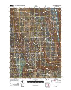
2011 Map of Crane Prairie
USGS Topo · Published 2011About this map
Crane Prairie serves as the central focal point of this high-altitude landscape in Grant County, characterized by an intricate network of forest service roads and drainage basins. The eastern edge of the quadrangle is defined by the course of the North Fork Malheur River, which collects water from numerous named canyons and gulches, including the deeply cut Telephone Gulch and Rattlesnake Canyon. This 2011 survey reveals the vital role of natural water sources in this environment, marking numerous isolated springs such as Winegar Spring, Roaring Spring, and Lost Camp Spring. These features, along with the North Fork Cow Camp in the northeast, reflect the historical and ongoing use of the area for seasonal grazing and wilderness management. High points like Sheep Mountain and Summit Rock provide orientation across the diverse terrain of the Blue Mountains province.
Find a feature on this map
20 named features on this map. Tap any name to fly to it.
Don’t see what you’re looking for? This feature index may not catch every label — zoom into the map to look around manually.
Map Details
Editions of this 2011 Crane Prairie Map
This is the sole edition of this map. No revisions or reprints were ever made.
Other maps of this area

1908 · Ironside Mountain
USGS Topo · 1:125,000

1955 · Canyon City
USGS Topo · 1:250,000

1959 · Canyon City
USGS Topo · 1:250,000

1959 · Prairie City
USGS Topo · 1:62,500

1961 · Logan Valley
USGS Topo · 1:62,500

1970 · Flag Prairie
USGS Topo · 1:62,500
1972 · Bullrun Rock
USGS Topo · 1:24,000
1972 · Little Baldy Mnt.
USGS Topo · 1:24,000

1978 · John Day
USGS Topo · 1:100,000
1988 · Logan Valley East
USGS Topo · 1:24,000