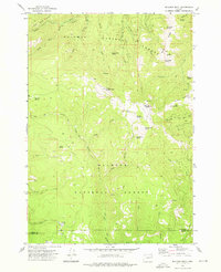
1972 Map of Bullrun Rock
USGS Topo · Published 1976About this map
Whitman National Forest and Malheur National Forest converge in this high-elevation wilderness, where the county line between Baker Co and Grant Co follows the jagged topography. Significant landmarks like Monument Rock, Table Rock, and Bullrun Rock dominate the central peaks, providing a network of springs including Smokey Bear Spring, Elk Wallow Spring, and Egg Spring that feed the local watershed. The drainage systems are clearly defined, showing the headwaters of the South Fork Malheur River and Little Malheur River alongside the North Fork West Camp Creek. Evidence of early land use is found in the scattered mines and the Gravel Pit near Prairie Hill, while the Burn area north of Big Cow Creek indicates the natural cycle of the forest. Navigation through this complex terrain is limited to the Lookout Road, Ditch Creek Trail, and various pack trails.
Find a feature on this map
39 named features on this map. Tap any name to fly to it.
Don’t see what you’re looking for? This feature index may not catch every label — zoom into the map to look around manually.
Map Details
Editions of this 1972 Bullrun Rock Map
2 editions found
Other maps of this area

1908 · Ironside Mountain
USGS Topo · 1:125,000

1955 · Canyon City
USGS Topo · 1:250,000

1959 · Canyon City
USGS Topo · 1:250,000

1970 · Flag Prairie
USGS Topo · 1:62,500

1970 · Castle Rock
USGS Topo · 1:62,500
1972 · Unity
USGS Topo · 1:24,000
1972 · Deardorff Mtn
USGS Topo · 1:24,000
1972 · Rail Gulch
USGS Topo · 1:24,000
1972 · Rastus Mtn
USGS Topo · 1:24,000
1972 · Little Baldy Mnt.
USGS Topo · 1:24,000