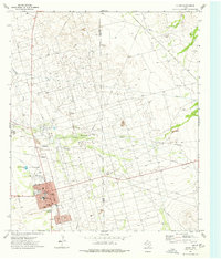
1974 Map of Crane
USGS Topo · Published 1977About this map
The McElroy Oil Field dominates this West Texas landscape, revealing a dense infrastructure of extraction during the mid-1970s. The town of Crane serves as the regional hub, densely packed with civic amenities including a Hosp, Lib, and the Crane-Bethune Sch. Beyond the residential grid, the landscape is defined by an intricate network of pipelines, aqueducts, and industrial sites like the Gas Plant and several Pumping Stations. These features underscore the region's total immersion in the petroleum industry, while the nearby Mayfield settlement and numerous Gravel Pits suggest a landscape continuously reshaped by resource demands. Traditional community life is anchored at the Rodeo Ground and Crane Memorial Gardens, situated just south of the County Airport. Drainage patterns like Landreth Draw cut through the industrial grid, marking the natural topography of the Permian Basin.
Find a feature on this map
31 named features on this map. Tap any name to fly to it.
Don’t see what you’re looking for? This feature index may not catch every label — zoom into the map to look around manually.
Map Details
Editions of this 1974 Crane Map
This is the sole edition of this map. No revisions or reprints were ever made.
Other maps of this area

1928 · Crane
USGS Topo · 1:125,000

1954 · Pecos
USGS Topo · 1:250,000

1957 · Pecos
USGS Topo · 1:250,000

1964 · Doodle Bug Well
USGS Topo · 1:24,000

1964 · Perkins Lake
USGS Topo · 1:24,000

1968 · Benge Corner SW
USGS Topo · 1:24,000

1971 · McElroy Ranch
USGS Topo · 1:24,000

1971 · Marlboro Canyon
USGS Topo · 1:24,000

1974 · Crane SW
USGS Topo · 1:24,000
1974 · Crane NW
USGS Topo · 1:24,000