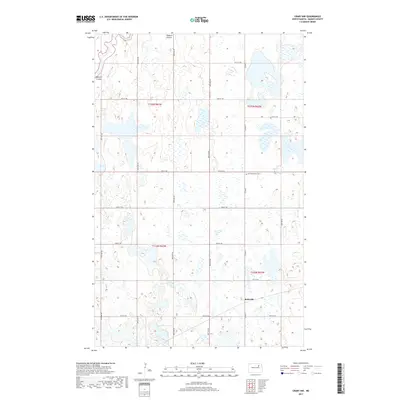
2017 Map of Crary NW
USGS Topo · Published 2017About this map
Rohrville anchors the southeastern corner of this North Dakota landscape, situated within a region defined by an extensive network of prairie wetlands and seasonal watercourses. The drainage of Edmore Coulee winds through the northern sections, cutting through the glacial till that characterizes this portion of Ramsey County. This 2017 survey illustrates the persistent section-line road grid, including routes from 50th St NE up to 57th St NE, which organizes the agricultural expanse. A significant site for local history and genealogy is Saint Benedicts Cem, located centrally near the intersection of several township boundaries. The map provides a contemporary look at the complex hydrology of the area, where numerous small potholes and basins dot the plains between the established townships of t155n r63w and t155n r62w.
Find a feature on this map
15 named features on this map. Tap any name to fly to it.
Don’t see what you’re looking for? This feature index may not catch every label — zoom into the map to look around manually.
Map Details
Editions of this 2017 Crary NW Map
This is the sole edition of this map. No revisions or reprints were ever made.
Other maps of this area

1931 · Devils Lake
USGS Topo · 1:62,500

1950 · Devils Lake
USGS Topo · 1:62,500

1951 · Crary
USGS Topo · 1:24,000

1951 · Devils Lake
USGS Topo · 1:24,000

1951 · Sweetwater
USGS Topo · 1:24,000

1953 · Devils Lake
USGS Topo · 1:250,000

1956 · Devils Lake
USGS Topo · 1:250,000

1957 · Starkweather SE
USGS Topo · 1:24,000

1971 · Southam
USGS Topo · 1:24,000
1971 · Crary NW
USGS Topo · 1:24,000