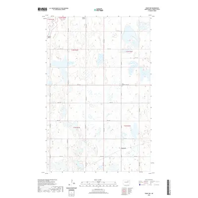
2020 Map of Crary NW
USGS Topo · Published 2020About this map
Rohrville anchors this part of Ramsey County, where the agricultural landscape of North Dakota is defined by an intricate network of wetlands and small water bodies. The terrain is marked by the meandering Edmore Coulee, which winds through the northern sections of the map. Local heritage is preserved at the Saint Benedicts Cem, situated along Co Hwy 3. This 2020 survey illustrates a strictly organized section-line road system, including routes from 50th St NE up to 57th St NE, which facilitates movement through this sparsely populated prairie region. The map provides a clear record of land divisions across several townships, including t155n r63w and t154n r62w, reflecting the enduring structure of the Great Plains' rural geography.
Find a feature on this map
16 named features on this map. Tap any name to fly to it.
Don’t see what you’re looking for? This feature index may not catch every label — zoom into the map to look around manually.
Map Details
Editions of this 2020 Crary NW Map
This is the sole edition of this map. No revisions or reprints were ever made.
Other maps of this area

1931 · Devils Lake
USGS Topo · 1:62,500

1950 · Devils Lake
USGS Topo · 1:62,500

1951 · Crary
USGS Topo · 1:24,000

1951 · Devils Lake
USGS Topo · 1:24,000

1951 · Sweetwater
USGS Topo · 1:24,000

1953 · Devils Lake
USGS Topo · 1:250,000

1956 · Devils Lake
USGS Topo · 1:250,000

1957 · Starkweather SE
USGS Topo · 1:24,000

1971 · Southam
USGS Topo · 1:24,000
1971 · Crary NW
USGS Topo · 1:24,000