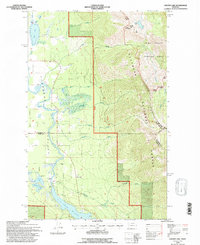
1994 Map of Crater Lake
USGS Topo · Published 1996About this map
Flathead National Forest land dominates this 1994 revision, capturing the intersection of the Flathead Range and the Swan River valley. The map details the high-altitude Jewel Basin Hiking Area, where Crater Mountain and Broken Leg Mountain overlook a landscape carved by drainage systems like Wolf Creek and Meadow Creek. Along the valley floor, the Swan River meanders toward the northern reaches of Swan Lake, passing by the Loon Lake Access and a State Highway Weigh Station. This survey reflects a managed wilderness era, showing the transition from mountain trails to the transport corridors of the Hungry Horse Swan Lake Rd and Spotted Bear Rd. Several Gravel Pits and a Gaging Sta near Loon Lake indicate the ongoing infrastructure and hydrological monitoring within this corner of Lake and Flathead Counties.
Find a feature on this map
30 named features on this map. Tap any name to fly to it.
Don’t see what you’re looking for? This feature index may not catch every label — zoom into the map to look around manually.
Map Details
Editions of this 1994 Crater Lake Map
This is the sole edition of this map. No revisions or reprints were ever made.
Other maps of this area

1914 · Nyack
USGS Topo · 1:125,000

1920 · Flathead Lake
USGS Topo · 1:125,000

1943 · Kalispell
USGS Topo · 1:125,000

1955 · Choteau
USGS Topo · 1:250,000

1956 · Wallace
USGS Topo · 1:250,000

1957 · Choteau
USGS Topo · 1:250,000

1957 · Kalispell
USGS Topo · 1:250,000

1958 · Choteau
USGS Topo · 1:250,000

1960 · Kalispell
USGS Topo · 1:250,000

1960 · Wallace
USGS Topo · 1:250,000