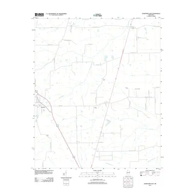
2012 Map of Crawford East
USGS Topo · Published 2012About this map
Crawford sits at the western edge of this Lowndes County landscape, serving as a primary point of settlement along Main St and Longstreet. The surrounding countryside is defined by an intricate network of waterways, including the winding James Cr, Horse Hunters Cr, and the uniquely named Broken Pumpkin Cr. The area's genealogical value is high, with several family-named burial sites such as Jennings Cem, Turner Cem, and Ledbetter Cem scattered across the rural acreage. Transport and infrastructure are represented by Carson Airport and a grid of local routes like W Lindsey Ferry Rd, which allude to the historical river crossings of the region. The map captures a transition where traditional agricultural lands are segmented by modern forestry roads like Weyerhaeuser Rd.
Find a feature on this map
53 named features on this map. Tap any name to fly to it.
Don’t see what you’re looking for? This feature index may not catch every label — zoom into the map to look around manually.
Map Details
Editions of this 2012 Crawford East Map
This is the sole edition of this map. No revisions or reprints were ever made.
Other maps of this area

1953 · West Point
USGS Topo · 1:250,000

1958 · West Point
USGS Topo · 1:250,000

1959 · Artesia
USGS Topo · 1:62,500

1960 · Columbus
USGS Topo · 1:62,500

1963 · West Point
USGS Topo · 1:250,000

1973 · Cliftonville
USGS Topo · 1:24,000
1973 · Brooksville
USGS Topo · 1:24,000
1973 · Lynn Creek
USGS Topo · 1:24,000

1984 · West Point
USGS Topo · 1:250,000
1987 · Columbus South
USGS Topo · 1:24,000