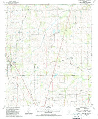
1987 Map of Crawford East
USGS Topo · Published 1987About this map
The town of Crawford serves as the primary hub of this 1980s landscape, situated along the Gulf Mobile and Mississippi railroad line. The surrounding rural terrain across the Lowndes and Noxubee county line is characterized by a dense network of family-named landmarks and country churches, reflecting the deep-rooted agricultural community of the era. Significant watercourses like South Branch Magowah Creek and James Creek drain the area, while the road network preserves historical memory through names like Lindsey Ferry Road. Local history and genealogy interests are well-represented by several religious and burial sites, including St James Ch, Prairie Grove Ch, and Ledbetter Cem. The southern portion of the map transitions into the drainage basin of Broken Pumpkin Creek, crisscrossed by modern infrastructure such as large pipelines and the north-south corridor of Seitz Road.
Find a feature on this map
38 named features on this map. Tap any name to fly to it.
Don’t see what you’re looking for? This feature index may not catch every label — zoom into the map to look around manually.
Map Details
Editions of this 1987 Crawford East Map
This is the sole edition of this map. No revisions or reprints were ever made.
Other maps of this area

1953 · West Point
USGS Topo · 1:250,000

1958 · West Point
USGS Topo · 1:250,000

1959 · Artesia
USGS Topo · 1:62,500

1960 · Columbus
USGS Topo · 1:62,500

1963 · West Point
USGS Topo · 1:250,000

1973 · Cliftonville
USGS Topo · 1:24,000
1973 · Brooksville
USGS Topo · 1:24,000
1973 · Lynn Creek
USGS Topo · 1:24,000

1984 · West Point
USGS Topo · 1:250,000
1987 · Columbus South
USGS Topo · 1:24,000