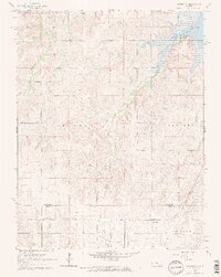
1964 Map of Crawford
USGS Topo · Published 1965About this map
Crawford sits along the southern edge of the central Kansas plains, positioned at the intersection of rural agriculture and early industrial extraction during the mid-1960s. The Missouri Pacific railroad cuts across the southern portion of the sheet, providing a vital link for the agricultural townships of Galt and Odessa while serving the emerging petroleum landscape of the Click Southeast Oil Field. The terrain is defined by the headwaters and drainages of Thompson Creek, Bluff Creek, and Horse Creek, which carve through the townships of Empire, Trivoli, and Langley. This survey captures the region as the Kanopolis Reservoir altered the northern hydrology, and local family history remains anchored in scattered sites like Scaife Cem, Click Cem, Liscum Cem, and Forest Grove Cem.
Find a feature on this map
18 named features on this map. Tap any name to fly to it.
Don’t see what you’re looking for? This feature index may not catch every label — zoom into the map to look around manually.
Map Details
Editions of this 1964 Crawford Map
2 editions found
Other maps of this area

1891 · Hutchinson
USGS Topo · 1:125,000

1892 · Salina
USGS Topo · 1:125,000

1893 · Hutchinson
USGS Topo · 1:125,000

1894 · Ellsworth
USGS Topo · 1:125,000

1894 · Lyons
USGS Topo · 1:125,000

1942 · Salina
USGS Topo · 1:125,000

1955 · Great Bend
USGS Topo · 1:250,000

1955 · Hutchinson
USGS Topo · 1:250,000

1957 · Great Bend
USGS Topo · 1:250,000

1957 · Ellsworth
USGS Topo · 1:24,000