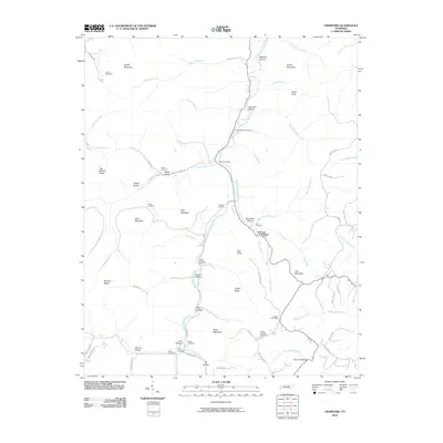
2010 Map of Crawford
USGS Topo · Published 2010About this map
The West Fork Obey River carves a deep path through this portion of Overton County, defining a landscape of high ridges and secluded hollows. At the time of this 2010 survey, the rural character of the region remains centered around scattered post offices and family burial grounds that trace generations of upland settlement. Small communities and historical landmarks are anchored by the Allred Post Office and Crawford Post Office, while the topography is dominated by significant elevations such as Alpine Mountain, Stout Mountain, and Egypt Knob. The map reveals a high density of named hollows and ridges, including Hog Wallow Ridge and Medlock Hollow, which suggest a long history of local naming conventions tied to specific families and terrain features. Numerous cemeteries like Shiloh Cemetery and Phillips Cemetery are tucked into the hillsides, offering essential data for genealogists tracking local ancestry.
Find a feature on this map
73 named features on this map. Tap any name to fly to it.
Don’t see what you’re looking for? This feature index may not catch every label — zoom into the map to look around manually.
Map Details
Editions of this 2010 Crawford Map
This is the sole edition of this map. No revisions or reprints were ever made.
Other maps of this area

1897 · Standingstone
USGS Topo · 1:125,000

1898 · Standingstone
USGS Topo · 1:125,000

1935 · Clarkrange
USGS Topo · 1:24,000

1943 · Cookeville
USGS Topo · 1:100,000

1944 · Cookeville
USGS Topo · 1:100,000

1944 · Livingston
USGS Topo · 1:24,000

1946 · Clarkrange
USGS Topo · 1:24,000

1946 · Obey City
USGS Topo · 1:24,000
1950 · Clarkrange
USGS Topo · 1:24,000
1950 · Obey City
USGS Topo · 1:24,000