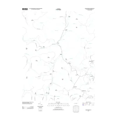
2013 Map of Crawford
USGS Topo · Published 2013About this map
The W Fork Obey River carves a deep path through this portion of the Cumberland Plateau, anchoring a series of small Tennessee settlements including Allred, Shiloh, and Crawford. The landscape is defined by its dramatic relief, where narrow hollows like Solomon Hollow and Katy Hollow sit thousands of feet below prominent heights such as Alpine Mountain and Stout Mountain. This 2013 topographic survey captures the intricate network of rural roads that navigate these ridges, from the winding Hickory Flat Rd to the secluded Pioneer Trail Ln. The settlement pattern follows the drainage of the river and its many tributaries, such as Big Laurel Cr and Little Indian Cr, where family-named landmarks like Norrod Hollow and Obe Lee Hollow point to a deep-rooted history of local land ownership. This survey provides a modern spatial context for the small communities of Twinton and Windletown, showing how the geography continues to shape the character of Overton County.
Find a feature on this map
93 named features on this map. Tap any name to fly to it.
Don’t see what you’re looking for? This feature index may not catch every label — zoom into the map to look around manually.
Map Details
Editions of this 2013 Crawford Map
This is the sole edition of this map. No revisions or reprints were ever made.
Other maps of this area

1897 · Standingstone
USGS Topo · 1:125,000

1898 · Standingstone
USGS Topo · 1:125,000

1935 · Clarkrange
USGS Topo · 1:24,000

1943 · Cookeville
USGS Topo · 1:100,000

1944 · Cookeville
USGS Topo · 1:100,000

1944 · Livingston
USGS Topo · 1:24,000

1946 · Clarkrange
USGS Topo · 1:24,000

1946 · Obey City
USGS Topo · 1:24,000
1950 · Clarkrange
USGS Topo · 1:24,000
1950 · Obey City
USGS Topo · 1:24,000