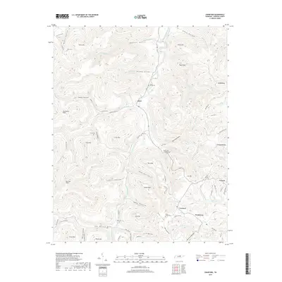
2019 Map of Crawford
USGS Topo · Published 2019About this map
West Fork Obey River cuts through the center of this Overton County landscape, carving deep hollows into the Cumberland Plateau. The settlement pattern follows these valleys and ridges, with communities like Allred, Twinton, and Crawford serving as primary hubs of activity. The rugged topography is defined by prominent elevations such as Alpine Mtn and Egypt Knob, while numerous family and community burial grounds, including Allred Cem and Speck Cem, are scattered along the narrow roads that wind through the hills. This 2019 survey documents a region where naming conventions remain deeply rooted in the land, with geographic features like Hog Wallow Ridge and Daddy Ridge illustrating local vernacular. The map traces the intricate network of creeks and branches, such as Puncheon Camp Cr and Big Laurel Cr, that have shaped the rural development and transit routes of the area.
Find a feature on this map
87 named features on this map. Tap any name to fly to it.
Don’t see what you’re looking for? This feature index may not catch every label — zoom into the map to look around manually.
Map Details
Editions of this 2019 Crawford Map
This is the sole edition of this map. No revisions or reprints were ever made.
Other maps of this area

1897 · Standingstone
USGS Topo · 1:125,000

1898 · Standingstone
USGS Topo · 1:125,000

1935 · Clarkrange
USGS Topo · 1:24,000

1943 · Cookeville
USGS Topo · 1:100,000

1944 · Cookeville
USGS Topo · 1:100,000

1944 · Livingston
USGS Topo · 1:24,000

1946 · Clarkrange
USGS Topo · 1:24,000

1946 · Obey City
USGS Topo · 1:24,000
1950 · Clarkrange
USGS Topo · 1:24,000
1950 · Obey City
USGS Topo · 1:24,000