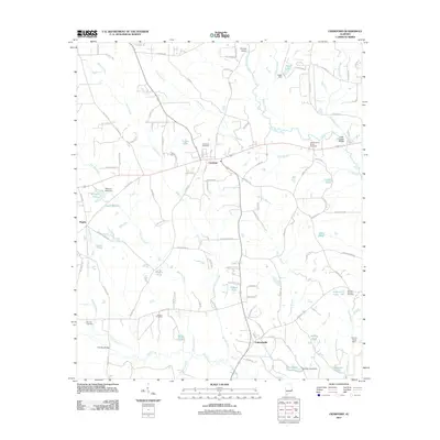
2011 Map of Crawford
USGS Topo · Published 2011About this map
Crawford serves as a central hub in this section of Russell County, where local roads such as Lee Road 179 and Lee Road 206 converge near the Crawford Cemetery. The landscape is defined by a dense network of tributaries including Island Creek, Maringo Creek, and Little Uchee Creek, which feed into numerous named reservoirs like Williams Lake and Dudley Lake. This hydrological pattern is reflected in the many small bridges and dams throughout the area, such as Bishops Bridge and the Heath Dam. To the east, the East Alabama Motor Speedway stands out as a prominent landmark near Little Uchee Bridge. Southward, the settlement of Parkmanville is situated near Uchee Creek, illustrating the long-standing reliance on these waterways for defining community boundaries and infrastructure. Genealogists will find interest in the scattered burial grounds, including the Bennett Cemetery and Jowers Cemetery, which anchor the rural landscape.
Find a feature on this map
109 named features on this map. Tap any name to fly to it.
Don’t see what you’re looking for? This feature index may not catch every label — zoom into the map to look around manually.
Map Details
Editions of this 2011 Crawford Map
This is the sole edition of this map. No revisions or reprints were ever made.
Other maps of this area

1907 · Opelika
USGS Topo · 1:125,000

1909 · Opelika
USGS Topo · 1:125,000

1914 · Seale
USGS Topo · 1:62,500

1949 · Fort Mitchell
USGS Topo · 1:24,000

1950 · Crawford
USGS Topo · 1:24,000

1950 · Seale
USGS Topo · 1:24,000

1950 · Phenix City
USGS Topo · 1:24,000

1950 · Seale
USGS Topo · 1:62,500

1955 · Phenix City
USGS Topo · 1:24,000

1955 · Seale
USGS Topo · 1:24,000