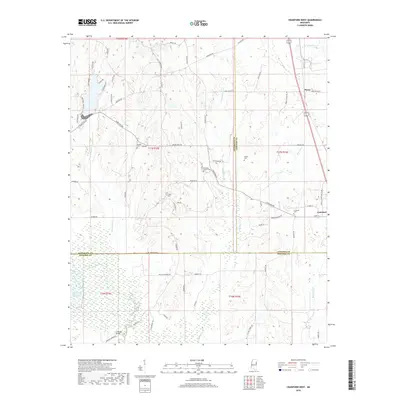
2018 Map of Crawford West
USGS Topo · Published 2018About this map
The town of Crawford sits near the eastern edge of this landscape, positioned along the corridor of Alt 45 and the north-flowing Shotbag Cr. The region is defined by its transition from the agricultural uplands down toward the winding course of the Noxubee River and Oktoc Cr in the south. This area is heavily marked by family-named burial grounds and rural churches, including Bethesda Baptist Cem, Crigler Cem, and Henkle Cem, reflecting a long-standing pattern of family landholdings across Lowndes and Oktibbeha counties. In the northern reaches, the small settlement of Penns and the headwaters of Rocky Bottom Cr highlight the rural development that persists away from the main transit lines. Further south, the landscape shifts toward more managed water features and wetlands, such as Green Timber Reservoir Number Two and the crossing at Edmonds Bridge.
Find a feature on this map
74 named features on this map. Tap any name to fly to it.
Don’t see what you’re looking for? This feature index may not catch every label — zoom into the map to look around manually.
Map Details
Editions of this 2018 Crawford West Map
This is the sole edition of this map. No revisions or reprints were ever made.
Other maps of this area

1953 · West Point
USGS Topo · 1:250,000

1958 · West Point
USGS Topo · 1:250,000

1959 · Artesia
USGS Topo · 1:62,500

1963 · West Point
USGS Topo · 1:250,000

1965 · Starkville
USGS Topo · 1:24,000

1965 · Bluff Lake
USGS Topo · 1:24,000
1973 · Brooksville
USGS Topo · 1:24,000
1973 · Barge Lake
USGS Topo · 1:24,000
1973 · Lynn Creek
USGS Topo · 1:24,000

1984 · West Point
USGS Topo · 1:250,000