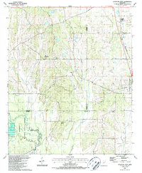
1987 Map of Crawford West
USGS Topo · Published 1987About this map
Noxubee National Wildlife Refuge dominates the southwestern corner of this survey, where the Noxubee River and its tributaries, including Minnow Creek and Loakfoma Creek, create a complex network of wetlands and reservoirs such as Green Timber Reservoir No 2. This drainage pattern contrasts with the settlement to the northeast, where the town of Crawford sits along the Gulf and Mississippi rail line. The landscape is marked by several small rural congregations and cemeteries, such as Bethesda Ch and Pleasant Grove Ch (Cem), serving as vital markers of local history at the junction of Oktibbeha, Lowndes, and Noxubee counties. In the north, the Gulf and Mississippi railroad corridor passes through Swedenborg, while prominent landmarks like Sam Hill and the B L Moor High Sch orient the central rural district.
Find a feature on this map
31 named features on this map. Tap any name to fly to it.
Don’t see what you’re looking for? This feature index may not catch every label — zoom into the map to look around manually.
Map Details
Editions of this 1987 Crawford West Map
This is the sole edition of this map. No revisions or reprints were ever made.
Other maps of this area

1953 · West Point
USGS Topo · 1:250,000

1958 · West Point
USGS Topo · 1:250,000

1959 · Artesia
USGS Topo · 1:62,500

1963 · West Point
USGS Topo · 1:250,000

1965 · Starkville
USGS Topo · 1:24,000

1965 · Bluff Lake
USGS Topo · 1:24,000
1973 · Brooksville
USGS Topo · 1:24,000
1973 · Barge Lake
USGS Topo · 1:24,000
1973 · Lynn Creek
USGS Topo · 1:24,000

1984 · West Point
USGS Topo · 1:250,000