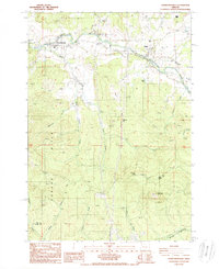
1988 Map of Crawfordsville
USGS Topo · Published 1988About this map
The Calapooia River meanders through the northern reaches of this territory, anchoring the communities of Crawfordsville and Holley. This late twentieth-century survey captures the landscape as it transitions from the river valley into the elevated terrain of the Bickmore Hills and the Coburg Hills. Local infrastructure is marked by several quarries and a prominent network of transmission lines, reflecting the area's resource-based activities. To the west, McKercher Park and a local cemetery near the river point to established community hubs. Further south, the terrain becomes increasingly complex, rising toward Grassy Mountain and Georges Knob before reaching the Linn Co Lane Co boundary. The map also details the headwaters of numerous creeks, such as Brush Creek and Shotgun Creek, which define the drainage patterns of these timbered uplands.
Find a feature on this map
24 named features on this map. Tap any name to fly to it.
Don’t see what you’re looking for? This feature index may not catch every label — zoom into the map to look around manually.
Map Details
Editions of this 1988 Crawfordsville Map
This is the sole edition of this map. No revisions or reprints were ever made.
Other maps of this area

1911 · Brownsville
USGS Topo · 1:31,680

1921 · Brownsville
USGS Topo · 1:62,500

1950 · Marcola
USGS Topo · 1:62,500

1950 · Brownsville
USGS Topo · 1:62,500

1951 · Sweet Home
USGS Topo · 1:62,500

1951 · Leaburg
USGS Topo · 1:62,500

1952 · Brownsville
USGS Topo · 1:62,500

1952 · Marcola
USGS Topo · 1:62,500

1953 · Salem
USGS Topo · 1:250,000

1954 · Salem
USGS Topo · 1:250,000