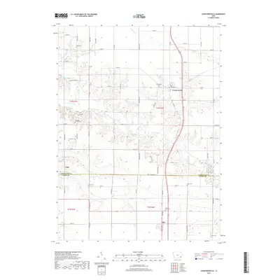
2018 Map of Crawfordsville
USGS Topo · Published 2018About this map
Crawfordsville stands as the primary hub in this corner of southeastern Iowa, situated just north of the Washington Co Henry Co line. The landscape is defined by the drainage networks of Crooked Creek and its branches, including West Fork Crooked Creek and East Fork Crooked Creek, which carve deep contours into the surrounding farmland. This agricultural area is anchored by smaller communities like Olds and the settlement of Noble, with a high density of rural burial grounds that offer significant genealogical value. Family researchers will find several notable sites, such as North Wayne Cem near the southern border and the Fern Cliff Evangelic Cem tucked near Fern Cliff Rd. The grid of section roads, from 282nd St down to 120th St, provides a precise framework for locating ancestral homesteads and legacy farmsteads across the townships.
Find a feature on this map
45 named features on this map. Tap any name to fly to it.
Don’t see what you’re looking for? This feature index may not catch every label — zoom into the map to look around manually.
Map Details
Editions of this 2018 Crawfordsville Map
This is the sole edition of this map. No revisions or reprints were ever made.
Other maps of this area

1958 · Davenport
USGS Topo · 1:250,000

1961 · Davenport
USGS Topo · 1:250,000

1962 · Davenport
USGS Topo · 1:250,000

1969 · Washington
USGS Topo · 1:24,000

1970 · Cotter
USGS Topo · 1:24,000

1970 · Ainsworth
USGS Topo · 1:24,000

1980 · Trenton
USGS Topo · 1:24,000

1980 · Wayland
USGS Topo · 1:24,000
1981 · Crawfordsville
USGS Topo · 1:24,000
1981 · Winfield North
USGS Topo · 1:24,000