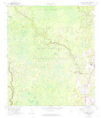
1972 Map of Crawfordville West
USGS Topo · Published 1973About this map
Apalachicola National Forest dominates the landscape of this western Wakulla County survey, where the low-lying terrain of Cow Swamp, Mill Bay, and Grimes Bay creates a complex network of wetlands. In the early 1970s, the western reaches of Crawfordville were characterized by scattered homesteads and timber operations, evidenced by the Pope Still Lookout Tower and an Old Railroad Grade that speaks to earlier industrial logging efforts. The Sopchoppy River and Lost Creek wind through the timberlands, providing drainage for the various bays and ditches. Local social centers are anchored by small communities like Arran and Lawhons Mill, alongside religious landmarks such as Mt Clifton Ch and Mt Olive Ch. Genealogists will find several burial grounds noted, including Oak Park Cem and Council Cem, reflecting the deep-rooted family history in this corner of the Florida Panhandle.
Find a feature on this map
32 named features on this map. Tap any name to fly to it.
Don’t see what you’re looking for? This feature index may not catch every label — zoom into the map to look around manually.
Map Details
Editions of this 1972 Crawfordville West Map
2 editions found
Other maps of this area

1940 · Tallahassee
USGS Topo · 1:62,500

1940 · Arran
USGS Topo · 1:62,500

1942 · Tallahassee
USGS Topo · 1:62,500

1943 · Arran
USGS Topo · 1:62,500

1943 · Tallahassee
USGS Topo · 1:62,500

1943 · Lake Talquin
USGS Topo · 1:62,500

1945 · Bradwell Bay
USGS Topo · 1:31,680

1945 · Sanborn
USGS Topo · 1:31,680

1954 · Tallahassee
USGS Topo · 1:250,000

1959 · Tallahassee
USGS Topo · 1:250,000