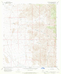
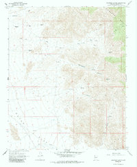
1967 Map of Creamery Canyon
USGS Topo · Published 1970About this map
Hualapai Mts dominate the eastern landscape of this 1967 survey, where high-elevation drainage systems like Cottonwood Canyon and Creamery Canyon carve through the arid terrain. The map captures a critical water-management network essential for cattle and survival in the Arizona high desert, documented through features like Blue Mary Spring, Haystack Tank, and Cottonwood Spring. To the west, the topography softens into the broad expanse of Dutch Flat, where the Alamo Road and various unnamed jeep trails provided the primary means of traversal through the scrubland. This document preserves the mid-century layout of ranching infrastructure, marking several water tanks and cattle-related landmarks alongside seasonal watercourses such as Mackenzie Wash and Bar I-L Wash. The presence of a solitary Prospect near the mountain foothills hints at the region's mineral exploration history during this era.
Find a feature on this map
20 named features on this map. Tap any name to fly to it.
Don’t see what you’re looking for? This feature index may not catch every label — zoom into the map to look around manually.
Map Details
Editions of this 1967 Creamery Canyon Map
2 editions found
Other maps of this area

1923 · Signal
USGS Topo · 1:250,000
1927 · Yucca
USGS Topo · 1:62,500

1927 · Buck Mountains
USGS Topo · 1:62,500

1929 · Buck Mountains
USGS Topo · 1:62,500
1929 · Yucca
USGS Topo · 1:62,500

1942 · Signal
USGS Topo · 1:250,000

1950 · Prescott
USGS Topo · 1:250,000

1954 · Needles
USGS Topo · 1:250,000

1954 · Prescott
USGS Topo · 1:250,000

1956 · Needles
USGS Topo · 1:250,000