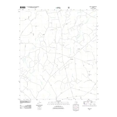
2011 Map of Crecy
USGS Topo · Published 2011About this map
The small settlements of Crecy and Centerville anchor this portion of Trinity County, where a complex network of waterways dictates the local landscape. The map reveals how local roads like Chic Watson Rd and Moore Cemetery Rd navigate between the drainages of Black Lake Creek and Mossy Creek. This area's rural character is emphasized by the presence of several established burial grounds, including Moore Cemetery, McClain Cemetery, and Bennett Cemetery, which serve as vital landmarks for genealogists tracing the inhabitants of these East Texas timberlands. The hydrological pattern is particularly dense in the south, where Scrub Creek, Piney Creek, and Alabama Creek converge, creating a rugged environment that has historically influenced the placement of farms and transit routes such as the Helmic-Centerville Rd.
Find a feature on this map
35 named features on this map. Tap any name to fly to it.
Don’t see what you’re looking for? This feature index may not catch every label — zoom into the map to look around manually.
Map Details
Editions of this 2011 Crecy Map
This is the sole edition of this map. No revisions or reprints were ever made.
Other maps of this area

1950 · Centralia
USGS Topo · 1:24,000

1951 · Kennard
USGS Topo · 1:24,000

1951 · Wells SW
USGS Topo · 1:24,000

1951 · Centralia
USGS Topo · 1:24,000

1953 · Palestine
USGS Topo · 1:250,000

1957 · Palestine
USGS Topo · 1:250,000

1963 · Crecy
USGS Topo · 1:24,000

1963 · Groveton West
USGS Topo · 1:24,000
1963 · Pennington
USGS Topo · 1:24,000

1963 · Groveton East
USGS Topo · 1:24,000