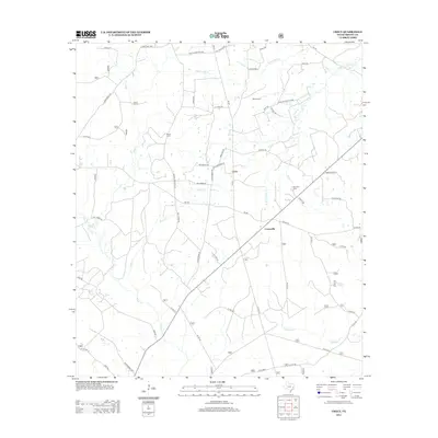
2013 Map of Crecy
USGS Topo · Published 2013About this map
Centerville and the small settlement of Crecy anchor this Trinity County landscape, defined by a dense network of creek bottoms and low-lying drainages. The area is heavily intersected by local routes like FM 233 and FM 357, which connect scattered homesteads and timberlands between the waters of Piney Cr and Alabama Cr. Significant family markers and burial grounds are found throughout the interior, including Moore Cem, McLain Cem, and Bennett Cem, providing essential points of reference for genealogists tracking early East Texas residents. The survey detail illuminates the transition from upland ridges to the lowlands of Terry Ingram Bottom near Cedar Cr. This 2013 edition preserves the rural character of the region before further modern development, documenting the winding course of Black Lake Cr and the complex system of forest roads that define this part of the Pineywoods.
Find a feature on this map
52 named features on this map. Tap any name to fly to it.
Don’t see what you’re looking for? This feature index may not catch every label — zoom into the map to look around manually.
Map Details
Editions of this 2013 Crecy Map
This is the sole edition of this map. No revisions or reprints were ever made.
Other maps of this area

1950 · Centralia
USGS Topo · 1:24,000

1951 · Kennard
USGS Topo · 1:24,000

1951 · Wells SW
USGS Topo · 1:24,000

1951 · Centralia
USGS Topo · 1:24,000

1953 · Palestine
USGS Topo · 1:250,000

1957 · Palestine
USGS Topo · 1:250,000

1963 · Crecy
USGS Topo · 1:24,000

1963 · Groveton West
USGS Topo · 1:24,000
1963 · Pennington
USGS Topo · 1:24,000

1963 · Groveton East
USGS Topo · 1:24,000