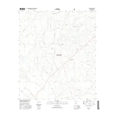
2016 Map of Crecy
USGS Topo · Published 2016About this map
Davy Crockett National Forest dominates much of this Trinity County landscape, where the small communities of Crecy and Centerville are linked by a network of winding county roads and forest routes. This 2016 survey illustrates the persistent rural character of eastern Texas, centered around the drainage basins of Piney Cr and Alabama Cr. Genealogists will find several family-named landmarks and resting places, including Moore Cem, McLain Cem, and Bennett Cem, which are scattered throughout the wooded terrain. The topography is defined by low-lying floodplains like Terry Ingram Bottom and a dense web of smaller tributaries such as Mossy Cr and Scrub Cr. The map's road network, featuring names like Rex Bailey Rd and Chic Watson Rd, provides a modern look at property access and land use within the national forest boundaries.
Find a feature on this map
47 named features on this map. Tap any name to fly to it.
Don’t see what you’re looking for? This feature index may not catch every label — zoom into the map to look around manually.
Map Details
Editions of this 2016 Crecy Map
This is the sole edition of this map. No revisions or reprints were ever made.
Other maps of this area

1950 · Centralia
USGS Topo · 1:24,000

1951 · Kennard
USGS Topo · 1:24,000

1951 · Wells SW
USGS Topo · 1:24,000

1951 · Centralia
USGS Topo · 1:24,000

1953 · Palestine
USGS Topo · 1:250,000

1957 · Palestine
USGS Topo · 1:250,000

1963 · Crecy
USGS Topo · 1:24,000

1963 · Groveton West
USGS Topo · 1:24,000
1963 · Pennington
USGS Topo · 1:24,000

1963 · Groveton East
USGS Topo · 1:24,000