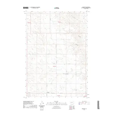
2021 Map of Creighton
USGS Topo · Published 2021About this map
The settlement of Creighton serves as the central hub for this high-plains landscape in Pennington County. The topography is defined by significant drainage systems, including Three Tree Draw, Fourmile Draw, and Seven-D-Draw, which cut through the terrain toward Deep Cr. For genealogists and local historians, the presence of the Creighton Cem and Emmanuel Lutheran Cem provides specific points of interest for family research. The area's water sources, such as Hammann Lake and the N Fork Rainy Cr, reflect the critical role of water management in this agricultural region. The map also delineates the rural road network, with primary thoroughfares like Creighton Rd and Wall Pedro Rd connecting the scattered homesteads and section lines of the Public Land Survey System.
Find a feature on this map
23 named features on this map. Tap any name to fly to it.
Don’t see what you’re looking for? This feature index may not catch every label — zoom into the map to look around manually.
Map Details
Editions of this 2021 Creighton Map
This is the sole edition of this map. No revisions or reprints were ever made.
Other maps of this area

1953 · Rapid City
USGS Topo · 1:250,000

1954 · Dalzell SE
USGS Topo · 1:24,000

1954 · Wasta NE
USGS Topo · 1:24,000

1954 · Dalzell NE
USGS Topo · 1:24,000

1955 · Pedro
USGS Topo · 1:24,000

1955 · Pedro NW
USGS Topo · 1:24,000

1955 · Creighton
USGS Topo · 1:24,000

1955 · Pedro SE
USGS Topo · 1:24,000

1957 · Rapid City
USGS Topo · 1:250,000
1983 · Horse Tooth
USGS Topo · 1:24,000