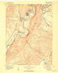
1951 Map of Cresaptown
USGS Topo · Published 1951About this map
The North Branch Potomac River serves as the winding border between Maryland and West Virginia, carving a deep valley between Dans Mtn and Knobly Mountain. This mid-century landscape is defined by its industrial and transit corridors, where the Baltimore and Ohio and Western Maryland railroads parallel the river, passing through key rail points like McKenzie and Pinto Sta. The map captures the infrastructure of the era, including the Chesapeake and Ohio Canal (Abandoned) and aviation sites like the Cumberland Municipal Airport and Mexico Farm Landing Field. Smaller communities such as Amcelle and Cresaptown are centered around these arteries. In the southeastern corner, the village of Fort Ashby stands near the Patterson Creek valley, surrounded by family landmarks like the Cecil Cem and Lease Cem.
Find a feature on this map
48 named features on this map. Tap any name to fly to it.
Don’t see what you’re looking for? This feature index may not catch every label — zoom into the map to look around manually.
Map Details
Editions of this 1951 Cresaptown Map
This is the sole edition of this map. No revisions or reprints were ever made.
Other maps of this area

1891 · Romney
USGS Topo · 1:125,000

1898 · Frostburg
USGS Topo · 1:62,500

1899 · Flintstone
USGS Topo · 1:62,500

1900 · Flintstone
USGS Topo · 1:62,500

1901 · Frostburg
USGS Topo · 1:62,500

1908 · Frostburg
USGS Topo · 1:62,500

1920 · Keyser
USGS Topo · 1:62,500

1921 · Keyser
USGS Topo · 1:48,000

1921 · Hanging Rock
USGS Topo · 1:48,000

1922 · Keyser
USGS Topo · 1:62,500