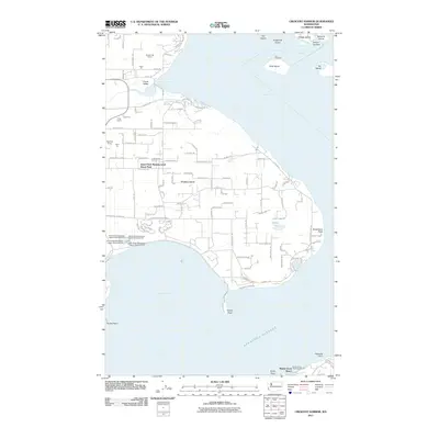
2011 Map of Crescent Harbor
USGS Topo · Published 2011About this map
Fort Whitman on Goat Island stands as a prominent historical landmark at the entrance to Skagit Bay, marking the maritime gateway between Whidbey Island and Fidalgo Island. This 2011 survey illustrates the complex northern coastline of Whidbey, where the residential footprint of Island Park Manufactured Home Park and the rural agricultural tracts of Clover Valley meet the shoreline. The landscape is defined by its industrial activity and coastal geography, featuring several resource extraction sites such as the Boulder Hill Quarry, Krieg Quarry, and Shepherd Quarry. Along the eastern shore, the transition from the protected waters of Crescent Harbor to the open Saratoga Passage is punctuated by significant landforms like Polnell Point and the recreation areas at Maple Grove Beach. The map also captures modern infrastructure, including the series of wastewater lagoons supporting the nearby population centers.
Find a feature on this map
117 named features on this map. Tap any name to fly to it.
Don’t see what you’re looking for? This feature index may not catch every label — zoom into the map to look around manually.
Map Details
Editions of this 2011 Crescent Harbor Map
This is the sole edition of this map. No revisions or reprints were ever made.
Other maps of this area

1911 · Mount Vernon
USGS Topo · 1:125,000

1939 · Coupeville
USGS Topo · 1:62,500

1940 · Mt Vernon
USGS Topo · 1:62,500

1943 · Mt Vernon
USGS Topo · 1:62,500

1943 · Stanwood
USGS Topo · 1:62,500

1943 · Deception Pass
USGS Topo · 1:62,500

1951 · Deception Pass
USGS Topo · 1:62,500

1953 · Coupeville
USGS Topo · 1:24,000

1953 · Camano
USGS Topo · 1:24,000
1956 · Utsalady
USGS Topo · 1:24,000