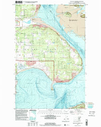
1998 Map of Crescent Harbor
USGS Topo · Published 2002About this map
Whidbey Island Naval Air Station dominates the central landscape of this northern Whidbey Island study, reflecting the area's continued military importance through the late twentieth century. The map illustrates a complex coastal environment where the deep waters of Saratoga Passage and Crescent Harbor meet the shallow, shifting channels of the Skagit River delta. Local road networks like Polnell Road and Taylor Road connect the military installation to coastal points and small residential clusters. To the north, the Skagit Wildlife Recreation Area covers several small islands, including Goat Island and Sugarloaf Island, showing the preservation of the estuary alongside industrial and military developments. The presence of numerous gravel and borrow pits near Dugualla Bay suggests ongoing infrastructure support for the island's naval facilities and expanding residential footprint.
Find a feature on this map
42 named features on this map. Tap any name to fly to it.
Don’t see what you’re looking for? This feature index may not catch every label — zoom into the map to look around manually.
Map Details
Editions of this 1998 Crescent Harbor Map
This is the sole edition of this map. No revisions or reprints were ever made.
Other maps of this area

1911 · Mount Vernon
USGS Topo · 1:125,000

1939 · Coupeville
USGS Topo · 1:62,500

1940 · Mt Vernon
USGS Topo · 1:62,500

1943 · Mt Vernon
USGS Topo · 1:62,500

1943 · Stanwood
USGS Topo · 1:62,500

1943 · Deception Pass
USGS Topo · 1:62,500

1951 · Deception Pass
USGS Topo · 1:62,500

1953 · Coupeville
USGS Topo · 1:24,000

1953 · Camano
USGS Topo · 1:24,000
1956 · Utsalady
USGS Topo · 1:24,000