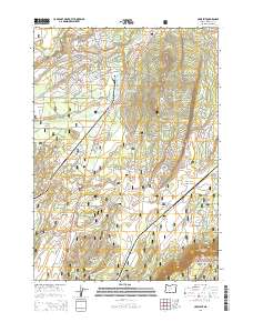
2014 Map of Crescent
USGS Topo · Published 2014About this map
Gilchrist and Crescent sit at the center of this high-desert landscape in the early 21st century, defined by the logging history and natural boundaries of Central Oregon. The presence of the Gilchrist Log Pond and Gilchrist Reservoir points to the area's industrial legacy, while the Little Deschutes River and Crescent Cr wind through the terrain. The map shows the convergence of the Deschutes National Forest and Winema National Forest, highlighting a transition between protected woodlands and local grazing areas like Odell Pasture. Prominent geographical markers such as Crescent Butte and the elevation change at Walker Rim provide a clear view of the local topography. This survey details a comprehensive network of Forest Service roads, including Nat For Dev Rd 9775 and the Gilchrist Haul Rd, illustrating the modern infrastructure supporting timber and recreation.
Find a feature on this map
34 named features on this map. Tap any name to fly to it.
Don’t see what you’re looking for? This feature index may not catch every label — zoom into the map to look around manually.
Map Details
Editions of this 2014 Crescent Map
This is the sole edition of this map. No revisions or reprints were ever made.
Other maps of this area

1930 · Maiden Peak
USGS Topo · 1:125,000

1934 · Maiden Peak
USGS Topo · 1:125,000

1935 · Chemult
USGS Topo · 1:96,000

1941 · Chemult
USGS Topo · 1:125,000

1955 · Crescent
USGS Topo · 1:250,000

1957 · Crescent
USGS Topo · 1:250,000

1958 · Crescent
USGS Topo · 1:250,000

1963 · Hamner Butte
USGS Topo · 1:24,000

1963 · Masten Butte
USGS Topo · 1:24,000
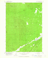
1963 · Cryder Butte
USGS Topo · 1:24,000