
1963 Map of Masten Butte
USGS Topo · Published 1965About this map
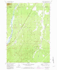
Little Deschutes River meanders through the western half of this landscape, its complex oxbows and wetlands carving a distinct path through the Deschutes National Forest. Along its banks, the Wagon Trail Ranch suggests the mid-century development of residential pockets within this predominantly timbered region. To the east, the Great Northern railroad line runs nearly parallel to the river, serving as a primary industrial artery through the high plateau. The terrain is relatively flat, punctuated by Long Prairie and the eponymous Masten Butte in the northwest corner. This 1963 survey captures the area at a time of transitioning land use, where infrastructure like the Radio Tower and South La Pine Roadside Rest appear alongside the established railroad settlement at Beal. The boundary between Deschutes Co and Klamath Co bisects the northern and eastern portions of the sheet, marking a significant administrative divide in the Oregon backcountry.
Find a feature on this map
12 named features on this map. Tap any name to fly to it.
Don’t see what you’re looking for? This feature index may not catch every label — zoom into the map to look around manually.
Map Details
Editions of this 1963 Masten Butte Map
2 editions found
Other maps of this area

1930 · Maiden Peak
USGS Topo · 1:125,000

1931 · Newberry Crater
USGS Topo · 1:125,000

1934 · Maiden Peak
USGS Topo · 1:125,000

1935 · Chemult
USGS Topo · 1:96,000

1935 · Newberry Crater
USGS Topo · 1:125,000

1941 · Chemult
USGS Topo · 1:125,000

1955 · Crescent
USGS Topo · 1:250,000

1957 · Crescent
USGS Topo · 1:250,000

1958 · Crescent
USGS Topo · 1:250,000

1963 · La Pine
USGS Topo · 1:24,000