
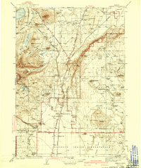
1941 Map of Chemult
USGS Topo · Published 1941About this map
Chemult and the high desert plateau of central Oregon are defined here by a dense network of volcanic peaks and timber operations. During the mid-1930s, the region was a critical corridor for both the Southern Pacific and Great Northern railroads, which facilitated the growth of timber towns like Gilchrist and logging outposts such as Lumber Camp 1 and Lumber Camp 2. The landscape is a complex of cinder cones and buttes, including Odell Butte, Black Rock Butte, and the prominent Walker Mtn, which sits east of the primary rail line.
Find a feature on this map
109 named features on this map. Tap any name to fly to it.
Don’t see what you’re looking for? This feature index may not catch every label — zoom into the map to look around manually.
Map Details
Editions of this 1941 Chemult Map
2 editions found
Other maps of this area

1889 · Klamath
USGS Topo · 1:250,000

1891 · Ashland
USGS Topo · 1:250,000

1893 · Ashland
USGS Topo · 1:250,000

1894 · Klamath
USGS Topo · 1:250,000

1897 · Ashland
USGS Topo · 1:250,000

1917 · Diamond Lake
USGS Topo · 1:125,000

1925 · Waldo Lake
USGS Topo · 1:125,000

1930 · Maiden Peak
USGS Topo · 1:125,000

1931 · Newberry Crater
USGS Topo · 1:125,000

1934 · Maiden Peak
USGS Topo · 1:125,000