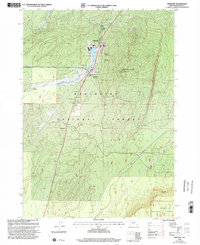
1999 Map of Crescent
USGS Topo · Published 2002About this map
Gilchrist and Crescent anchor this late 20th-century landscape in Klamath County, where the lumber industry and national forest management define the local geography. The industrial presence is marked by a Burner and a Cinder Pit, while the town sites are clustered along the Little Deschutes River. This revision reflects the area's dual identity as a working forest and a recreation hub, with public spaces like Bingham Park and the Boundary Spring Campground situated amidst the timberlands. Dramatic geological features such as Crescent Butte and the rising elevation of Walker Rim provide a striking backdrop to the settlement. The map documents the infrastructure of these timber towns, from the High Sch at Gilchrist to the water management of the Gilchrist Reservoir and Crescent Reservoir.
Find a feature on this map
20 named features on this map. Tap any name to fly to it.
Don’t see what you’re looking for? This feature index may not catch every label — zoom into the map to look around manually.
Map Details
Editions of this 1999 Crescent Map
This is the sole edition of this map. No revisions or reprints were ever made.
Other maps of this area

1930 · Maiden Peak
USGS Topo · 1:125,000

1934 · Maiden Peak
USGS Topo · 1:125,000

1935 · Chemult
USGS Topo · 1:96,000

1941 · Chemult
USGS Topo · 1:125,000

1955 · Crescent
USGS Topo · 1:250,000

1957 · Crescent
USGS Topo · 1:250,000

1958 · Crescent
USGS Topo · 1:250,000

1963 · Hamner Butte
USGS Topo · 1:24,000

1963 · Masten Butte
USGS Topo · 1:24,000
1963 · Cryder Butte
USGS Topo · 1:24,000