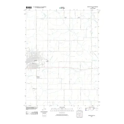
2010 Map of Creston East
USGS Topo · Published 2010About this map
The municipal center of Creston and its residential expansion into East Creston anchor this study of south-central Iowa’s agricultural and hydrological landscape. The town’s grid is centered around the Creston Post Office, while the southern reaches are dominated by the Creston Municipal Airport and the sprawling grounds of Graceland Cemetery. Beyond the city limits, the terrain is defined by a dense network of sectional roads and significant water bodies, most notably Three Mile Lake and Twelve Mile Lake. These reservoirs, along with the meandering courses of the Middle Platte River, East Platte River, and the headwaters of the Grand River, reveal the region's managed water resources. Small rural landmarks like Jerusalem Cemetery and Evergreen Cemetery provide focal points for local history amidst the surrounding farmland.
Find a feature on this map
44 named features on this map. Tap any name to fly to it.
Don’t see what you’re looking for? This feature index may not catch every label — zoom into the map to look around manually.
Map Details
Editions of this 2010 Creston East Map
This is the sole edition of this map. No revisions or reprints were ever made.
Other maps of this area

1951 · Afton
USGS Topo · 1:62,500

1954 · Omaha
USGS Topo · 1:250,000

1955 · Nebraska City
USGS Topo · 1:250,000

1957 · Nebraska City
USGS Topo · 1:250,000

1957 · Omaha
USGS Topo · 1:250,000

1958 · Omaha
USGS Topo · 1:250,000

1958 · Nebraska City
USGS Topo · 1:250,000

1980 · Creston East
USGS Topo · 1:24,000

1981 · Zion
USGS Topo · 1:24,000
1981 · Orient
USGS Topo · 1:24,000