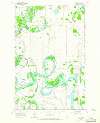
1962 Map of Creston
USGS Topo · Published 1966About this map
The Flathead River meanders through a complex network of oxbows and backwaters in this 1962 field-checked study. The landscape is defined by its dramatic hydrology, featuring numerous named waterways such as Egan Slough, Church Slough, and Half Moon Slough that illustrate the shifting course of the river over time. In the northwest, the Stillwater Game Preserve encompasses the confluence where the Stillwater River joins the Flathead, marking a significant conservation zone. The small settlement of Creston and nearby Lake Blaine anchor the eastern side of the sheet. For local historians, the map preserves the locations of several rural education centers, including Fairview Sch, Montford Sch, and Egan Sch, providing a clear record of mid-century community infrastructure before later consolidation. This area of Flathead County shows a distinct transition between protected wetlands and the agricultural grids that surround these vital water systems.
Find a feature on this map
21 named features on this map. Tap any name to fly to it.
Don’t see what you’re looking for? This feature index may not catch every label — zoom into the map to look around manually.
Map Details
Editions of this 1962 Creston Map
3 editions found
Other maps of this area

1943 · Kalispell
USGS Topo · 1:125,000

1957 · Kalispell
USGS Topo · 1:250,000

1960 · Kalispell
USGS Topo · 1:250,000

1961 · Kalispell
USGS Topo · 1:250,000

1962 · Columbia Falls South
USGS Topo · 1:24,000

1962 · Doris Mountain
USGS Topo · 1:24,000

1962 · Rose Crossing
USGS Topo · 1:24,000

1962 · Lion Mountain
USGS Topo · 1:24,000

1962 · Somers
USGS Topo · 1:24,000

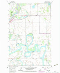
1962 · Creston
USGS Topo · 1:24,000