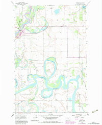
1962 Map of Creston
USGS Topo · Published 1983About this map
The Flathead River dominates this landscape, winding through a complex system of backwaters and oxbows in the Flathead Valley. The intricate hydrology of the area is defined by features like Egan Slough, Church Slough, and McWenneger Slough, illustrating the dynamic nature of the river's floodplain. This survey captures a rural Montana community organized around small settlements like Montford and Creston, where the social fabric is anchored by local institutions such as Egan Sch, Fairview Sch, and Hodgson Sch.
Find a feature on this map
20 named features on this map. Tap any name to fly to it.
Don’t see what you’re looking for? This feature index may not catch every label — zoom into the map to look around manually.
Map Details
Editions of this 1962 Creston Map
3 editions found
Other maps of this area

1943 · Kalispell
USGS Topo · 1:125,000

1957 · Kalispell
USGS Topo · 1:250,000

1960 · Kalispell
USGS Topo · 1:250,000

1961 · Kalispell
USGS Topo · 1:250,000

1962 · Columbia Falls South
USGS Topo · 1:24,000

1962 · Doris Mountain
USGS Topo · 1:24,000

1962 · Rose Crossing
USGS Topo · 1:24,000

1962 · Lion Mountain
USGS Topo · 1:24,000

1962 · Somers
USGS Topo · 1:24,000

1962 · Creston
USGS Topo · 1:24,000