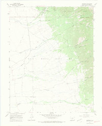
1967 Map of Crestone
USGS Topo · Published 1971About this map
Crestone sits at the base of the Sangre de Cristo Mountains, serving as a gateway between the high peaks of the Rio Grande National Forest and the vast private lands of the Luis Maria Baca No 4 grant. This late 1960s survey documents a landscape defined by its mining and transportation history, featuring an Old Railroad Grade and numerous mines and prospects tucked into canyons like Copper Gulch.
Find a feature on this map
32 named features on this map. Tap any name to fly to it.
Don’t see what you’re looking for? This feature index may not catch every label — zoom into the map to look around manually.
Map Details
Editions of this 1967 Crestone Map
6 editions found
Other maps of this area

1954 · Trinidad
USGS Topo · 1:250,000

1954 · Pueblo
USGS Topo · 1:250,000

1955 · Trinidad
USGS Topo · 1:250,000

1957 · Pueblo
USGS Topo · 1:250,000

1958 · Trinidad
USGS Topo · 1:250,000

1958 · Pueblo
USGS Topo · 1:250,000

1959 · Trinidad
USGS Topo · 1:250,000

1959 · Electric Peak
USGS Topo · 1:62,500
1959 · Horn Peak
USGS Topo · 1:24,000

1962 · Pueblo
USGS Topo · 1:250,000