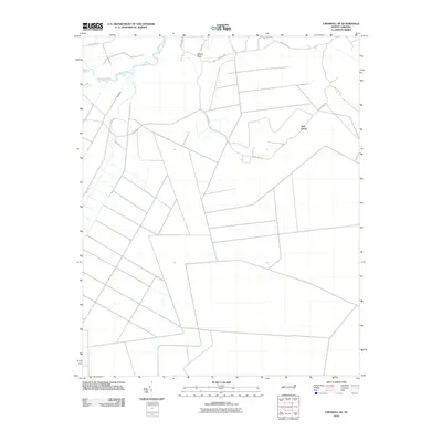
2010 Map of Creswell SE
USGS Topo · Published 2010About this map
The Scuppernong River meanders through this portion of Tyrrell County, defining the northern landscape alongside the Old Canal. The area is characterized by an extensive network of drainage ditches and straight-line roads, illustrating the organized agricultural development of the low-lying coastal plain. Small settlements such as Ballast Bank and the appropriately named New Lands provide focal points for local history research. The grid of rural routes, including Saint David Rd and Newlands Rd, highlights a pattern of land use where the natural waterway of the river contrasts with the engineered precision of the surrounding fields. This survey captures a moment in the early 21st century when the balance between the historic river system and modern large-scale agriculture was clearly established.
Find a feature on this map
12 named features on this map. Tap any name to fly to it.
Don’t see what you’re looking for? This feature index may not catch every label — zoom into the map to look around manually.
Map Details
Editions of this 2010 Creswell SE Map
This is the sole edition of this map. No revisions or reprints were ever made.
Other maps of this area

1943 · Columbia
USGS Topo · 1:125,000

1953 · Columbia East
USGS Topo · 1:24,000

1953 · Scotia
USGS Topo · 1:24,000

1953 · Columbia West
USGS Topo · 1:24,000

1953 · Fairfield NW
USGS Topo · 1:24,000

1953 · Rocky Mount
USGS Topo · 1:250,000

1954 · Rocky Mount
USGS Topo · 1:250,000
1954 · Creswell
USGS Topo · 1:24,000
1954 · Creswell SE
USGS Topo · 1:24,000
1954 · New Lake
USGS Topo · 1:24,000