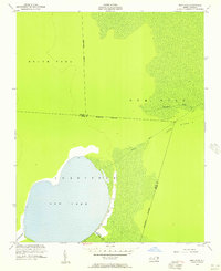
1954 Map of New Lake
USGS Topo · Published 1957About this map
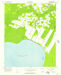
New Lake dominates this coastal landscape in the mid-1950s, its shoreline defined by a series of drainage projects including the Old State Canal and Souyars Canal. The terrain is marked by the low-lying reaches of South Fork and Gum Neck, where the Southwest Fork and New Lake Fork meander through marshy ground. Mapping by the U.S. Coast and Geodetic Survey reveals a sparsely populated area where human intervention is primarily seen in the road and canal network. Along the eastern edge of the lake, New Lake Road passes several sets of ruins, suggesting a previous era of activity near the water. The map also delineates the Hyde and Tyrrell County boundary as it cuts across Long Ridge and the Dunbar Canal, illustrating how political lines were surveyed through this wet, coastal forest and swamp environment.
Find a feature on this map
16 named features on this map. Tap any name to fly to it.
Don’t see what you’re looking for? This feature index may not catch every label — zoom into the map to look around manually.
Map Details
Editions of this 1954 New Lake Map
4 editions found
Other maps of this area

1943 · Columbia
USGS Topo · 1:125,000

1951 · Fairfield
USGS Topo · 1:24,000

1951 · Ponzer
USGS Topo · 1:24,000

1951 · New Lake SE
USGS Topo · 1:24,000

1953 · Scotia
USGS Topo · 1:24,000

1953 · Fairfield NW
USGS Topo · 1:24,000

1953 · Rocky Mount
USGS Topo · 1:250,000

1954 · Rocky Mount
USGS Topo · 1:250,000
1954 · Creswell
USGS Topo · 1:24,000
1954 · Creswell SE
USGS Topo · 1:24,000