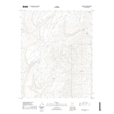
2020 Map of Crevasse Canyon
USGS Topo · Published 2020About this map
The Chuska Mountains define the high-elevation landscape of this McKinley County quadrangle, where deep-cut drainage systems like Crevasse Canyon carve through the plateau. This area of the Fort Defiance Agency is marked by a complex network of ephemeral waterways, including Twin Buttes Wash and Slick Rock Wash, which channel seasonal runoff toward the desert floor. The map shows a landscape largely shaped by natural contours, with human presence marked by high-altitude trails and the remote Logging Rd 8010.
Find a feature on this map
15 named features on this map. Tap any name to fly to it.
Don’t see what you’re looking for? This feature index may not catch every label — zoom into the map to look around manually.
Map Details
Editions of this 2020 Crevasse Canyon Map
This is the sole edition of this map. No revisions or reprints were ever made.
Other maps of this area

1886 · Wingate
USGS Topo · 1:250,000

1886 · Fort Defiance
USGS Topo · 1:250,000

1892 · Fort Defiance
USGS Topo · 1:250,000

1892 · Wingate
USGS Topo · 1:250,000

1954 · Gallup
USGS Topo · 1:250,000

1955 · Zith-Tusayan Butte 4 NE
USGS Topo · 1:24,000

1955 · Zith-Tusayan Butte 1 SE
USGS Topo · 1:24,000
1955 · Zith-Tusayan Butte 1 NE
USGS Topo · 1:24,000

1955 · Tohatchi
USGS Topo · 1:62,500
1955 · Buell Park
USGS Topo · 1:62,500