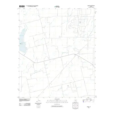
2010 Map of Crews
USGS Topo · Published 2010About this map
Crews sits at the junction of FM 382 and several county roads, serving as a focal point for this rural landscape in Runnels County. The terrain is defined by an intricate network of waterways, including the winding Gap Creek, Mud Creek, and Eagle Branch, which carve through the ranching and petroleum lands. The western edge of the area is dominated by the reservoir of Lake Winters, held by the Lake Winters Dam on Elm Creek.
Find a feature on this map
39 named features on this map. Tap any name to fly to it.
Don’t see what you’re looking for? This feature index may not catch every label — zoom into the map to look around manually.
Map Details
Editions of this 2010 Crews Map
This is the sole edition of this map. No revisions or reprints were ever made.
Other maps of this area

1890 · Abilene
USGS Topo · 1:125,000

1892 · Abilene
USGS Topo · 1:125,000

1892 · Ballinger
USGS Topo · 1:125,000

1921 · Hatchel
USGS Topo · 1:31,680

1954 · Brownwood
USGS Topo · 1:250,000

1954 · Abilene
USGS Topo · 1:250,000

1958 · Abilene
USGS Topo · 1:250,000
1967 · Hatchel
USGS Topo · 1:24,000

1967 · Talpa
USGS Topo · 1:24,000

1967 · Novice West
USGS Topo · 1:24,000