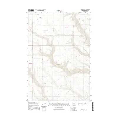
2017 Map of Crider Valley
USGS Topo · Published 2017About this map
Crider Valley and the surrounding drainage basins of Klickitat County are mapped here in high detail, revealing a landscape defined by sharp elevation changes and seasonal watercourses. The drainage of Alder Cr cuts deeply through the central portion of the quadrangle, while Stegeman Canyon and the elevated Sand Ridge provide prominent geographic landmarks to the north. This 2017 survey reflects the modern rural infrastructure of the region, where a network of long-established section roads like Stegeman Rd and Crider Valley Rd follow the natural contours of the valley floor and ridge lines. Further south, Sixprong Cr and Pine Cr snake through the terrain, highlighting the hydraulic patterns that have influenced land use and travel in this part of Washington for generations.
Find a feature on this map
21 named features on this map. Tap any name to fly to it.
Don’t see what you’re looking for? This feature index may not catch every label — zoom into the map to look around manually.
Map Details
Editions of this 2017 Crider Valley Map
This is the sole edition of this map. No revisions or reprints were ever made.
Other maps of this area

1910 · Zillah
USGS Topo · 1:125,000

1916 · Arlington
USGS Topo · 1:125,000

1950 · Yakima
USGS Topo · 1:250,000

1953 · The Dalles
USGS Topo · 1:250,000

1956 · The Dalles
USGS Topo · 1:250,000

1957 · The Dalles
USGS Topo · 1:250,000

1958 · Yakima
USGS Topo · 1:250,000

1961 · Yakima
USGS Topo · 1:250,000
1962 · Douty Canyon
USGS Topo · 1:24,000

1962 · Heppner Junction
USGS Topo · 1:24,000