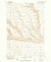
1962 Map of Douty Canyon
USGS Topo · Published 1963About this map
Sand Ridge dominates this Klickitat County landscape, part of a rugged drainage system where deep ravines like Douty Canyon and Tule Canyon carve into the high plateaus. The 1962 fieldwork reveals a remote territory defined by water scarcity and livestock management, evidenced by numerous named water sources such as Haggey Spring, Rattlesnake Spring, and Cottonwood Spring. The presence of several Storage Bins and a network of unimproved roads like Hale Road suggests a reliance on seasonal ranching and grain storage in these dry uplands.
Find a feature on this map
27 named features on this map. Tap any name to fly to it.
Don’t see what you’re looking for? This feature index may not catch every label — zoom into the map to look around manually.
Map Details
Editions of this 1962 Douty Canyon Map
2 editions found
Other maps of this area

1906 · Blalock Island
USGS Topo · 1:125,000

1908 · Blalock Island
USGS Topo · 1:125,000

1910 · Zillah
USGS Topo · 1:125,000

1915 · Prosser
USGS Topo · 1:125,000

1916 · Arlington
USGS Topo · 1:125,000

1917 · Prosser
USGS Topo · 1:125,000

1950 · Yakima
USGS Topo · 1:250,000

1953 · Pendleton
USGS Topo · 1:250,000

1953 · Walla Walla
USGS Topo · 1:250,000

1953 · The Dalles
USGS Topo · 1:250,000