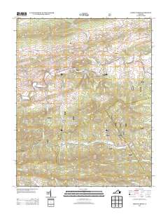
2013 Map of Cripple Creek
USGS Topo · Published 2013About this map
Raven Cliff Furnace and Eagle Furnace stand as markers of the iron industry that once defined this corridor of Wythe County. The landscape is deeply carved by the winding course of Cripple Creek, which flows past the small communities of Shiloh and Huddle. This 2013 survey illustrates a rural Appalachian environment where historic industrial sites are situated alongside recreational spaces like Raven Cliff Campground and Raven Cliff Horse Camp.
Find a feature on this map
86 named features on this map. Tap any name to fly to it.
Don’t see what you’re looking for? This feature index may not catch every label — zoom into the map to look around manually.
Map Details
Editions of this 2013 Cripple Creek Map
This is the sole edition of this map. No revisions or reprints were ever made.
Other maps of this area

1889 · Hillsville
USGS Topo · 1:125,000

1889 · Wytheville
USGS Topo · 1:125,000

1892 · Hillsville
USGS Topo · 1:125,000

1892 · Wytheville
USGS Topo · 1:125,000

1896 · Hillsville
USGS Topo · 1:125,000

1930 · Speedwell
USGS Topo · 1:62,500

1930 · Independence
USGS Topo · 1:48,000

1930 · Max Meadows
USGS Topo · 1:62,500

1931 · Galax
USGS Topo · 1:48,000

1933 · Independence
USGS Topo · 1:62,500