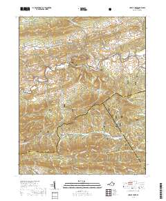
2019 Map of Cripple Creek
USGS Topo · Published 2019About this map
The eponymous Cripple Creek flows through a valley defined by early iron manufacturing and rural mountain settlements. This 2019 survey captures the geographic legacy of the region's industrial past, notably at Eagle Furnace and Noble Furnace, where the proximity to limestone and timber supported the local iron trade. Smaller communities like Henley, Huddle, and Shiloh are interspersed among the ridges, while Davis Cem remains a primary genealogical point of interest along Davis Cemetery Rd. To the south, the landscape shifts abruptly into the densely forested slopes of the Jefferson National Forest. Landmarks such as Raven Cliff and the high peaks of Iron Mountain dominate the southern portion of the sheet, where the Virginia Highlands define the border between Wythe, Grayson, and Carroll Counties. This modern record preserves the exact location of gaps and hollows like Mikes Gap and Devils Den that have guided travel through these mountains for generations.
Find a feature on this map
69 named features on this map. Tap any name to fly to it.
Don’t see what you’re looking for? This feature index may not catch every label — zoom into the map to look around manually.
Map Details
Editions of this 2019 Cripple Creek Map
This is the sole edition of this map. No revisions or reprints were ever made.
Other maps of this area

1889 · Hillsville
USGS Topo · 1:125,000

1889 · Wytheville
USGS Topo · 1:125,000

1892 · Hillsville
USGS Topo · 1:125,000

1892 · Wytheville
USGS Topo · 1:125,000

1896 · Hillsville
USGS Topo · 1:125,000

1930 · Speedwell
USGS Topo · 1:62,500

1930 · Independence
USGS Topo · 1:48,000

1930 · Max Meadows
USGS Topo · 1:62,500

1931 · Galax
USGS Topo · 1:48,000

1933 · Independence
USGS Topo · 1:62,500