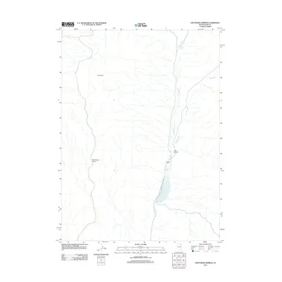
2012 Map of Crittenden Springs
USGS Topo · Published 2012About this map
Crittenden Ranch and the eponymous Crittenden Springs serve as the primary landmarks in this Elko County landscape. The area is defined by a series of drainage systems, most notably Granite Creek and Crittenden Creek, which feed into the Crittenden Reservoir. This water infrastructure suggests the ongoing importance of livestock ranching and water management in the high desert environment. To the west, the terrain rises toward Grassy Hill, while the local topography is further characterized by Schoolhouse Canyon and Long Canyon. Further north, Mill Creek Reservoir captures flow from Mill Creek, highlighting a pattern of catchment throughout the region. Several smaller waterways, including Silver Creek and Willow Creek, illustrate the complex network of seasonal and perennial streams that support the ranching operations and local ecology of this northeastern Nevada territory.
Find a feature on this map
12 named features on this map. Tap any name to fly to it.
Don’t see what you’re looking for? This feature index may not catch every label — zoom into the map to look around manually.
Map Details
Editions of this 2012 Crittenden Springs Map
This is the sole edition of this map. No revisions or reprints were ever made.
Other maps of this area

1955 · Wells
USGS Topo · 1:250,000

1958 · Wells
USGS Topo · 1:250,000

1961 · Wells
USGS Topo · 1:250,000

1961 · Delano Mountains
USGS Topo · 1:62,500

1961 · Dairy Valley
USGS Topo · 1:62,500

1967 · Jackson Spring
USGS Topo · 1:24,000

1967 · Twelvemile Ranch
USGS Topo · 1:24,000

1967 · Ninemile Mtn NE
USGS Topo · 1:24,000
1980 · Dry Canyon
USGS Topo · 1:24,000
1981 · Wells
USGS Topo · 1:100,000