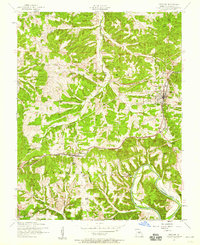
1954 Map of Crocker
USGS Topo · Published 1959About this map
Crocker serves as a primary rail hub for the mid-1950s Pulaski County landscape, situated where the ST Louis - San Francisco line cuts through the Ozark highlands. The settlement pattern reveals a series of tight-knit communities including Swedeborg and the small station of Gas, all connected by the central railroad corridor and a network of unimproved roads and ridge-top trails. Public life is anchored by local institutions such as Concord Church, Zion Church, and the Swedeborg School, alongside several family and community burial grounds like Swede Cemetery.
Find a feature on this map
31 named features on this map. Tap any name to fly to it.
Don’t see what you’re looking for? This feature index may not catch every label — zoom into the map to look around manually.
Map Details
Editions of this 1954 Crocker Map
2 editions found
Other maps of this area

1888 · Tuscumbia
USGS Topo · 1:125,000

1894 · Tuscumbia
USGS Topo · 1:125,000

1933 · Iberia
USGS Topo · 1:62,500

1936 · Waynesville
USGS Topo · 1:48,000

1937 · Iberia
USGS Topo · 1:62,500

1942 · Waynesville
USGS Topo · 1:62,500

1943 · Richland
USGS Topo · 1:62,500

1944 · Waynesville
USGS Topo · 1:62,500

1947 · Jefferson City
USGS Topo · 1:250,000

1948 · Tavern
USGS Topo · 1:62,500