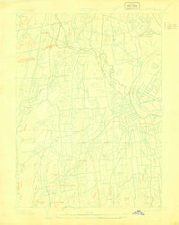
1928 Map of Cromwell
USGS Topo · Published 1928About this map
The Connecticut River serves as the dominant geographic feature of this 1928 survey, separating Cromwell and Portland as it flows past Middletown. The landscape is a complex network of smaller waterways and drainage patterns, including the Mattabesset River and its confluence with the Little River, alongside Sumner Brook and W Swamp Br. This edition is particularly notable for being an advance sheet compiled from aerial photographs taken by the Air Corps, documenting the region's infrastructure before significant mid-century suburban expansion.
Find a feature on this map
40 named features on this map. Tap any name to fly to it.
Don’t see what you’re looking for? This feature index may not catch every label — zoom into the map to look around manually.
Map Details
Editions of this 1928 Cromwell Map
This is the sole edition of this map. No revisions or reprints were ever made.
Other maps of this area

1892 · New Haven
USGS Topo · 1:62,500

1892 · Meriden
USGS Topo · 1:62,500
1893 · Guilford
USGS Topo · 1:62,500

1893 · Middletown
USGS Topo · 1:62,500

1893 · Meriden
USGS Topo · 1:62,500

1906 · Farmington
USGS Topo · 1:125,000
1921 · New Haven
USGS Topo · 1:62,500
1928 · Glastonbury
USGS Topo · 1:24,000
1943 · Durham
USGS Topo · 1:25,000
1944 · Hartford South
USGS Topo · 1:31,680