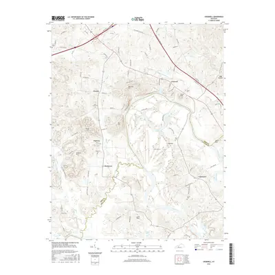
2016 Map of Cromwell
USGS Topo · Published 2016About this map
The Green River carves a massive, winding path through this western Kentucky landscape, defining the topography with its deep meanders at Big Bend and Little Bend. Along its banks and the neighboring ridges, the 2016 survey captures a network of small rural settlements including Cromwell, Shultztown, and Prentiss. The terrain is marked by prominent elevations like Tilford Knob and Keel Hill, while the lowlands near the river are dotted with significant water bodies such as Taylor Lake and Dotson Lake.
Find a feature on this map
83 named features on this map. Tap any name to fly to it.
Don’t see what you’re looking for? This feature index may not catch every label — zoom into the map to look around manually.
Map Details
Editions of this 2016 Cromwell Map
This is the sole edition of this map. No revisions or reprints were ever made.
Other maps of this area

1909 · Hartford
USGS Topo · 1:62,500

1911 · Dunmor
USGS Topo · 1:48,000

1914 · Little Muddy
USGS Topo · 1:62,500

1914 · Dunmor
USGS Topo · 1:62,500

1925 · Spring Lick
USGS Topo · 1:62,500

1953 · South Hill
USGS Topo · 1:24,000

1953 · Rochester
USGS Topo · 1:24,000

1954 · Evansville
USGS Topo · 1:250,000

1954 · Horton
USGS Topo · 1:24,000
1954 · Paradise
USGS Topo · 1:24,000