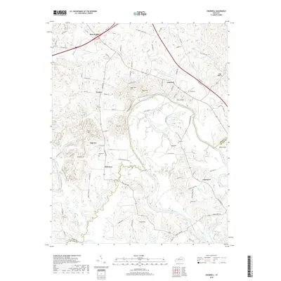
2019 Map of Cromwell
USGS Topo · Published 2019About this map
The Green River carves a massive, winding path through this portion of Ohio and Butler Counties, creating dramatic geographic features like Big Bend and Little Bend. This water-centric landscape is defined by its complex drainage systems, including the meandering Thoroughfare Stream and the swampy reaches of Hurricane Slough. The settlement pattern follows the high ground above the river valley, with several distinct communities established along the road networks. Beaver Dam sits in the northwest corner, while the namesake village of Cromwell is positioned near the river crossing, south of Negro Hill. Local family history is preserved in numerous rural burial grounds such as Slaty Creek Cem and Whalen Cem, which are scattered throughout the agricultural uplands. The terrain is marked by numerous named rises, including Tilford Knob and Taylor Hill, illustrating the dissected topography typical of the region before it drops toward the river's edge.
Find a feature on this map
91 named features on this map. Tap any name to fly to it.
Don’t see what you’re looking for? This feature index may not catch every label — zoom into the map to look around manually.
Map Details
Editions of this 2019 Cromwell Map
This is the sole edition of this map. No revisions or reprints were ever made.
Other maps of this area

1909 · Hartford
USGS Topo · 1:62,500

1911 · Dunmor
USGS Topo · 1:48,000

1914 · Little Muddy
USGS Topo · 1:62,500

1914 · Dunmor
USGS Topo · 1:62,500

1925 · Spring Lick
USGS Topo · 1:62,500

1953 · South Hill
USGS Topo · 1:24,000

1953 · Rochester
USGS Topo · 1:24,000

1954 · Evansville
USGS Topo · 1:250,000

1954 · Horton
USGS Topo · 1:24,000
1954 · Paradise
USGS Topo · 1:24,000