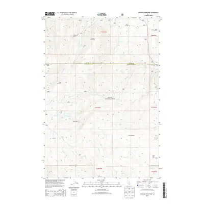
2013 Map of Crooked River Point
USGS Topo · Published 2013About this map
Payette National Forest dominates this Idaho landscape, where the high ridges of the Cuddy Mountains overlook a complex system of drainages and seasonal water sources. The map reveals a high-elevation environment marked by notable landmarks like the Devils Slide and Crooked River Point. Water management is evident in the western portion of the sheet through the presence of Hornet Reservoir and Lower Hornet Reservoir, which capture runoff from the surrounding peaks. In the south, Rush Lake and Buck Park suggest the type of mountain basins used for summer grazing or recreational purposes. The network of forest service routes, such as Crooked River Rd, provides the primary access through this remote terrain, following the natural paths carved by Crooked River and Hornet Cr.
Find a feature on this map
37 named features on this map. Tap any name to fly to it.
Don’t see what you’re looking for? This feature index may not catch every label — zoom into the map to look around manually.
Map Details
Editions of this 2013 Crooked River Point Map
This is the sole edition of this map. No revisions or reprints were ever made.
Other maps of this area

1955 · Baker
USGS Topo · 1:250,000

1957 · Cambridge
USGS Topo · 1:62,500

1957 · Copperfield
USGS Topo · 1:62,500

1957 · Hornet
USGS Topo · 1:62,500

1957 · Sturgill Peak
USGS Topo · 1:62,500

1959 · Baker
USGS Topo · 1:250,000

1980 · McCall
USGS Topo · 1:100,000

1986 · Peck Mountain
USGS Topo · 1:24,000
1986 · Crooked River Point
USGS Topo · 1:24,000
1986 · Rocky Comfort Flat
USGS Topo · 1:24,000