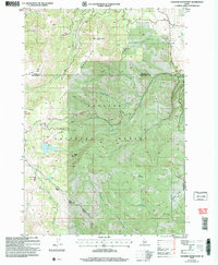
2004 Map of Crooked River Point
USGS Topo · Published 2007About this map
The Cuddy Mountains dominate this high-elevation landscape within the Payette National Forest, where steep ridgelines and deep drainage basins define the geography of the Adams and Washington County border. This 2004 revision details a region where water management and resource extraction have left a permanent mark, evidenced by the Hornet Reservoir and Lower Hornet Reservoir sitting alongside historical mining activity. Resource seekers can locate multiple prospects, Mine Shafts, and an Adit tucked away in the rugged slopes. The survey also identifies the Hornet Interpretive Site and several high-country landmarks like Devils Slide and Pyramid Point. Small settlements and seasonal camps appear at Buck Park and Olive Meadows, connected by forest service routes like the Council Weiser Ranger District road network.
Find a feature on this map
32 named features on this map. Tap any name to fly to it.
Don’t see what you’re looking for? This feature index may not catch every label — zoom into the map to look around manually.
Map Details
Editions of this 2004 Crooked River Point Map
This is the sole edition of this map. No revisions or reprints were ever made.
Other maps of this area

1955 · Baker
USGS Topo · 1:250,000

1957 · Cambridge
USGS Topo · 1:62,500

1957 · Copperfield
USGS Topo · 1:62,500

1957 · Hornet
USGS Topo · 1:62,500

1957 · Sturgill Peak
USGS Topo · 1:62,500

1959 · Baker
USGS Topo · 1:250,000

1980 · McCall
USGS Topo · 1:100,000

1986 · Peck Mountain
USGS Topo · 1:24,000
1986 · Crooked River Point
USGS Topo · 1:24,000
1986 · Rocky Comfort Flat
USGS Topo · 1:24,000